

Reviewed · AMSTERDAM CITY GAMES & SCAVENGER HUNTS
e-Scavenger hunt Utrecht: Explore the city at your own pace
Utrecht’s best feature is its compact old center, where a short walk can take you from the Dom Tower to a canal terrace, a medieval church, or a quiet courtyard. This self-guided e-scavenger hunt turns that walk into a game, sending you between major sights and less obvious corners without tying you to a guide or fixed schedule.
I like the freedom to stop for lunch, split the route across a relaxed afternoon, or race another team for points. I also like that the questions add a purpose to places you might otherwise pass quickly, from the flower market to the old workers’ quarter of De Zeven Steegjes.
The main drawback is uneven app performance and clue quality. Some questions and map pins may feel unclear, and the historical explanations are brief. Bring patience, mobile data, and a willingness to use your own curiosity when a clue falls short.
In This Review
- Key points to know before you book
- Starting beneath Utrecht’s famous Dom Tower
- Musical machines and Utrecht’s early churches
- The flower market and the Oudegracht
- Fortifications and the railway story
- Neude, Nicolaïkerk, and the old working-class streets
- City Hall, Paushuize, and rococo Utrecht
- A final quiet stop at Sterrehof
- How the app and scoring affect the experience
- Price, group size, and who gets the best value
- Should you book the Utrecht e-scavenger hunt?
- FAQ
- How long does the Utrecht e-scavenger hunt take?
- Where does the activity start?
- Where does the activity finish?
- How many people can join one group?
- Is the activity available in English?
- Do I need to bring a smartphone and mobile data?
- Can I cancel for a full refund?
Key points to know before you book

- Start at Domplein 20: The trail begins and ends in central Utrecht, close to the city’s most famous landmark.
- Expect 2 to 4 hours: Detours for food and drinks are easy, and one group reported walking about 10 kilometers.
- Play as one group or compete: The private activity allows up to six people, with a score table for friendly rivalry.
- See more than the headline sights: The route includes canals, churches, a flower market, courtyards, and the old railway area.
- Use your own phone and data: A smartphone and mobile connection are not included in the price.
- Best for independent explorers: You get flexibility, but not the depth or personal help of a live guide.
Starting beneath Utrecht’s famous Dom Tower
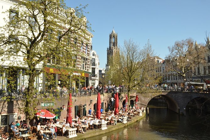
Begin at Domplein 20, in the shadow of the Dom Tower. At 112.5 meters, it is the tallest church tower in the Netherlands and Utrecht’s clearest symbol.
That makes this a sensible starting point. You get your bearings at once, and the opening stop gives the game a strong visual anchor. The square is also a useful place to gather your group, check the app, and make sure everyone has enough phone battery and data.
The route is not a traditional guided walk. No guide is waiting to explain the first building or keep you moving. Instead, the app directs your group and presents questions or tasks as you reach each point. That works well if you dislike fixed departure times, but you need to pay attention to the phone and to the surroundings at the same time.
The activity is available in English and runs every day according to the supplied schedule. Since the listed hours cover the full day, you can fit it around a morning arrival, an afternoon meal, or an evening stroll.
More city games and hunts in Utrecht:
- Discover Utrecht with a self-guided Outside Escape city game tour
★ 4.5 · 51 reviews - Escape Amsterdam: E-Bike to Zaanse Schans Windmills & Zaandam
★ 5.0 · 446 reviews - Amsterdam Treasure Hunt: The Mystery of a Secret Sender
★ 5.0 · 149 reviews
Musical machines and Utrecht’s early churches
One stop focuses on a collection of self-playing musical instruments, ranging from music boxes and clocks to pianolas and barrel organs. This is a welcome change of pace from a route made only of facades and dates. Mechanical music gives you a sense of how people entertained themselves before modern recording and streaming.
The exact format of this stop matters. The trail points you toward the collection, but the experience does not promise a private demonstration or museum admission. Treat it as a themed location within the game rather than a full museum visit.
The church stops provide the strongest historical backbone. One of the churches is among Utrecht’s oldest, with construction beginning in 1039 and inauguration on May 1, 1048. Another, the Janskerk, was founded shortly after 1040 by Bishop Bernold and is dedicated to John the Baptist.
These dates help you understand why Utrecht feels different from a modern Dutch city built around shops and offices. The old center is shaped by religious foundations, medieval streets, and buildings that have been adapted over centuries. The app’s questions can make you look more carefully, but do not expect long explanations at every point.
That limited context is worth keeping in mind. If you want a detailed account of Utrecht’s church architecture, this activity will leave gaps. If you want a reason to pause and notice old stonework, doorways, and square layouts, it does the job.
The flower market and the Oudegracht
The flower market is one of the more cheerful stops. It is described as colorful and comfortably busy, with cut flowers and plants on display. This gives the walk a sensory break from monuments and lets you see a piece of everyday city life.
Market conditions can change with the day and season, so do not treat it as a guaranteed long shopping stop. Its value is in the atmosphere and the visual variety. You can also use it as a natural point to slow down before continuing.
Next comes the Oudegracht, or old canal, the waterway that runs through the center of Utrecht. Restaurants sit along the canal, giving you a practical place to pause for coffee, lunch, or drinks.
The canal is one of the route’s strongest sections because it combines scenery with ordinary city use. You are not just looking at a preserved monument. You are walking beside terraces, water, bridges, and old buildings while people go about their day.
One group took detours, stopped for lunch and drinks, and walked about 10 kilometers. That is useful planning information. The official estimate is 2 to 4 hours, but your total distance and time can grow if you wander, stop often, or take the route as a loose guide rather than a strict line.
Fortifications and the railway story

The botanical garden appears farther out in the city experience. It sits on the Utrecht University campus around a former fort, part of the Holland Water Defence system.
This stop adds a layer of Dutch military and water engineering to the route. Utrecht’s story is not only churches and canals. Forts and controlled water lines were part of how the Netherlands protected itself.
The supplied information does not say that garden admission is included, so you should think of the location as part of the outdoor trail unless your booking details state otherwise. If you want a full botanical garden visit, allow extra time and check access separately.
The Railway Museum is another major stop, described as more than a standard museum and linked with Utrecht’s train history. The wording points to an attraction with a strong railway focus, but admission is not listed among the inclusions. The e-scavenger hunt takes you to the area or location as part of the route, not necessarily through every exhibit.
That distinction is important when budgeting. The ticket covers the city trail for your group. It does not list museum, garden, food, transport, or phone costs.
A few more Utrecht half-days to weigh up
- Amsterdam: 75 Minute City Canal Cruise with Audio Guide
★ 4.4 · 17,501 reviews - Amsterdam: Royal Palace Entry Ticket and Audio Guide
★ 4.6 · 6,475 reviews - Amsterdam: Canal Cruise with Live Commentary & Audio Guide
★ 4.4 · 1,034 reviews - Amsterdam Sightseeing Canal Cruise with Audio Guide
★ 3.5 · 828 reviews
Neude, Nicolaïkerk, and the old working-class streets
Neude is one of Utrecht’s best-known squares, but the clue adds a small piece of local geography. The name comes from node, meaning swamp, and the area used to be much lower than it is today.
That is exactly the kind of detail this activity handles well. You may already recognize the square, but the question gives you a reason to connect its present form with the ground beneath it.
The Nicolaïkerk, also called the Nicolaaskerk, sits at Nicolaaskerkhof 8. Its formal name and popular name can be useful for solving a question, especially if the app asks you to identify the church or match a fact to the correct building.
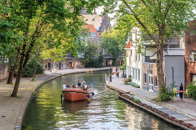
Then the trail leads toward De Zeven Steegjes, one of the last working-class neighborhoods in central Utrecht. Its characteristic workers’ houses sit near the Oudegracht.
This is one of the route’s more rewarding choices. Famous squares show you the city’s public face. Narrow residential lanes show you how ordinary people once lived in the center. The area also helps break up the sequence of churches and grand buildings.
You should keep your group respectful here. These are not empty historical sets. People live in the homes along these streets, and the best way to enjoy the neighborhood is to keep noise down and avoid blocking doorways.
City Hall, Paushuize, and rococo Utrecht

Utrecht City Hall brings the route back toward civic power. The oldest parts date from 806, and the building reached its present form after centuries of change.
The long timeline is more interesting than the building’s official function alone. A city hall with roots stretching back so far has been altered repeatedly to meet changing needs. Look for the contrast between old foundations, later additions, and the formal role the building still plays.
Paushuize, built at the beginning of the sixteenth century, is another important monument. It sits on Pausdam and is tied to the city’s ecclesiastical past.
These two stops work well together. One shows civic administration, the other religious and political influence. The app’s short prompts may not explain every connection, but they help you notice that Utrecht’s center was shaped by institutions as much as by trade and housing.
The Foundation Building on Agnietenstraat adds a later architectural note. Completed in 1761, it was originally a boarding school for orphaned boys and is considered one of the Netherlands’ notable rococo buildings.
This is a good example of the route’s range. You move from medieval churches to an eighteenth-century building with a different style and social purpose. If architectural terms are new to you, the game may prompt you to look closely at decoration and form, even if you later need to read more for a fuller explanation.
A final quiet stop at Sterrehof
Sterrehof is a courtyard in the city and a national monument. It provides a calmer ending than another busy square or major road.
Courtyards are easy to miss in Utrecht. They are often tucked behind ordinary entrances, so a self-guided route can be useful here. The game gives you a destination and a reason to look for spaces that are not obvious from the main street.
The route returns to the starting point at Domplein. That makes planning simple, especially if you have a restaurant reservation or need to continue to another part of Utrecht afterward.
Do not assume every group will finish in exactly the same time. Two hours is possible for a focused group that moves steadily. Four hours is more realistic if you read the prompts, take photos, stop at the canal, or pause at the market. A group taking its time may turn the activity into the framework for a full day.
How the app and scoring affect the experience
The app is the heart of the activity. It supplies directions, questions, hints, and bonus points. One useful tip is to tap the bonus-point option each time you reach the correct location. Missing that step can cost points even when you have found the place.
The scoring system gives the walk a clear game element. You can form separate teams and compare results, or keep everyone together and treat the questions as a shared puzzle. A final score table adds a little competition without forcing the whole outing into a race.
The app has mixed practical qualities. It is designed to be easy to navigate, and the interactive format works for different ages. At the same time, some map pins may sit far from the place where an answer is actually found. Hints can also be too vague or point in an unhelpful direction.
There have been occasional concerns about incorrect answers being accepted or checked at the location. That means you should not treat the app as infallible. If a clue seems wrong, note the issue and move on rather than letting one question spoil the afternoon.
The historical notes are also short. You get a prompt and a fact, not a full talk from a local guide. I see this as both a strength and a weakness: the pace stays light, but anyone wanting serious background will need to do extra reading.
Price, group size, and who gets the best value
The listed price is $37.21 per group of up to six people. With six participants, that works out to about $6.20 each, which is strong value for a 2 to 4 hour activity. With two people, the per-person cost is much higher, though you still get a private experience rather than joining strangers.
The price makes the most sense for families, friend groups, office outings, or two or three couples. It is also useful for a group that wants structure without paying for a private human guide.
You need to supply the smartphone and data. That is a small but important extra cost and practical requirement. Charge your phone before starting, and make sure the person holding the device can keep up with the walking group.
The activity is private, so only your group participates. Service animals are allowed, public transport is nearby, and the experience is described as suitable for most participants. It is also designed to be user-friendly for people with hearing impairment, since the main instructions are delivered through the phone rather than spoken by a guide.
Should you book the Utrecht e-scavenger hunt?
Book it if you want a flexible way to cover a lot of Utrecht while mixing sightseeing with puzzles. It is especially good for small groups, mixed ages, repeat visitors who want new corners of the center, and anyone who likes to stop for food without asking a guide to wait.
Think twice if you want detailed history, precise navigation, or polished museum interpretation. The route can lead you to places you might otherwise miss, but the explanations are light and the clues are not always perfect.
At $37.21 for up to six people, I would choose it for a relaxed group day, not as a substitute for a specialist walking tour. Bring a charged phone, use the bonus points, allow extra time for canal stops, and be ready to solve a few problems with common sense. That approach gives you the best chance of enjoying Utrecht’s churches, courtyards, canals, and everyday streets at your own speed.
FAQ
How long does the Utrecht e-scavenger hunt take?
The estimated duration is about 2 to 4 hours. Stopping for lunch, drinks, or extra sightseeing can make the outing longer.
Where does the activity start?
The starting point is Domplein 20, 3512 JD Utrecht, Netherlands.
Where does the activity finish?
The route ends back at the meeting point at Domplein 20.
How many people can join one group?
The private city trail is for a team of up to six people.
Is the activity available in English?
Yes. The experience is offered in English.
Do I need to bring a smartphone and mobile data?
Yes. A smartphone and data are not included, so you need to provide both.
Can I cancel for a full refund?
Yes, if you cancel at least 24 hours before the scheduled start time. Cancellations within 24 hours are not refunded, and changes within that period are not accepted.
More Scavenger Hunts in Utrecht
- e-Scavenger hunt Maastricht: Explore the city at your own pace
★ 4.5 · 110 reviews - e-Scavenger hunt Middelburg: Explore the city at your own pace
★ 4.5 · 55 reviews - e-Scavenger hunt Den Bosch: Explore the city at your own pace
★ 4.5 · 37 reviews - e-Scavenger hunt Deventer: Explore the city at your own pace
★ 4.0 · 34 reviews
Just added around Utrecht
- Utrecht Food Tour on a Bicycle with local guide★ 5.0 · 23 reviews
- Utrecht Quiz Tour★ 3.2 · 31 reviews
- Discover Our Utrecht: Limited Group Size & Optional Extras★ 5.0 · 32 reviews
- Utrecht: Lofen Palace with Entry Ticket & Guide (Dutch)★ 4.4 · 41 reviews
- From Amsterdam: Castle De Haar Guided Tour★ 4.7 · 41 reviews
- Utrecht: Ludwig’s Original Pub Crawl with VIP Club Entry★ 3.3 · 42 reviews
- Utrecht: Museum Speelklok Entry Ticket★ 4.5 · 48 reviews
- Discover Utrecht with a self-guided Outside Escape city game tour★ 4.5 · 51 reviews
Amsterdam City Games & Scavenger Hunts, compared.

Escape Amsterdam: E-Bike to Zaanse Schans Windmills & Zaandam
Read our review →
Amsterdam Treasure Hunt: The Mystery of a Secret Sender
Read our review →
e-Scavenger hunt Maastricht: Explore the city at your own pace
Read our review →
e-Scavenger hunt Middelburg: Explore the city at your own pace
Read our review →
Rotterdam Highlights & Spies: Interactive City Game
Read our review →
Discover Utrecht with a self-guided Outside Escape city game tour
Read our review →
Browse the lists this tour appears in